Hurricane Laura latest
12:45 pm
The tropical storm watch for Avoyelles That was set to expire at 12:45pm
has been extended until 9:15 tonight
11am
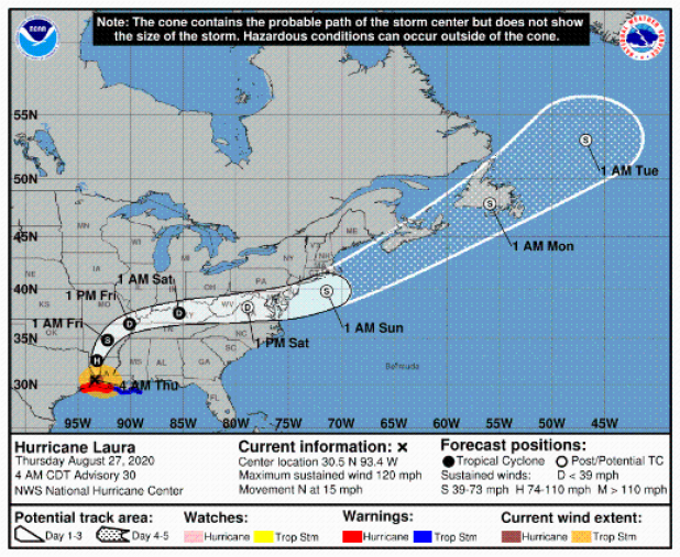
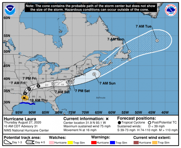
At 11 AM, Laura was located 50 miles east of Shreveport, moving north at 15 mph.
10 am
• Laura continues to weaken as it nears shreveport
* Avoyelles Parish has had one injury, numerous trees down and 16,000 power outages. A tree fell in Moreauville, striking a house and injuring a family member, Parish Emergency Preparedness Director Joey Frank said. Calls began coming in around 4 a.m.
9 am
* Laura downgraded to category 1
* Center west northwest of Avoyelles
* TROPICAL STORM WARNING REMAINS IN EFFECT for Avoyelles Paish until 12:45 pm today
8 am
* The eye of the storm is due west of Avoyelles.
* Laura remains Category 2 as it moves north through west Central Louisiana
* More power outages reported. Over 10,000 homes without electricity in parish
* National weather broadcasts are commenting how rare it is for a hurricane to remain so strong several hours after moving onto land. It is likely that Avoyelles Parish has never been this close to an eye of an actual hurricane. It remained a category two as it reached west Central Louisiana.
It was a Category five when it hit the coast south of Lake Charles at 1 am this morning. This the strongest hurricane to hit the Louisiana Coast since 1969 Camille (Hurricane Katrina was a Cat 3 when it came ashore, after weakening from a cat 5 when it was in open water).
As of 7:00
* Thousands of homes in Avoyelles are without electiricy.
* Winds are sustaned 36mph in Marksville
* Tropical Storm Warning in effect for Avoyelles until further notice
* Flash Flood Watch until August 27, 04:00 PM CDT
* Tornado Watch in effect from August 26, 09:00 PM CDT until August 27, 08:00 AM CDT
* Flash Flood Warning until August 27, 09:00 AM CDT
* KAPB radio in Marksville said the worst part in Avoyelles should be lessening in a couple of hours.
-----------------------------
FROM LAKE CHARLES NATIONAL WEATHER SERVICE
Here is the 6 am update on Hurricane Laura:
Location: 30.9°N 93.3°W
Moving: N at 15 mph
Min pressure: 964 mb
Max sustained: 105 mph
55 miles north of Lake Charles, LA
The eye of Hurricane Laura is moving from DeRidder to Leesville. It will be north of Vernon Parish around 8 am.
Hurricane force winds are likely in parts of east Texas and central Louisiana through 9 am.
Sustained tropical storm force winds will decrease between 8 am and noon for the I-10 corridor, and between 10 am and 2 pm for east Texas and central Louisiana.
Tides have leveled out at the coast, but water is still rising inland, in particular the Lake Charles area, southern Jeff Davis Parish, southern Acadia Parish, and inland sections of Cameron and Vermilion Parishes.
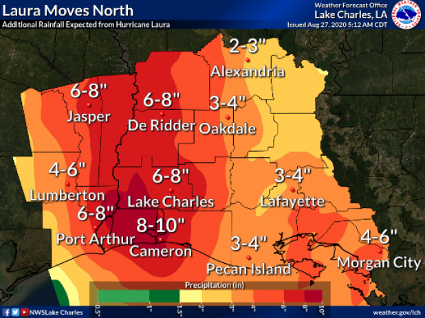
Rain totals of 5 to 10 inches or more is causing significant street flooding across many parts of our entire region.
Roger Erickson
Warning Coordination Meteorologist
National Weather Service
Lake Charles, LA